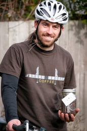
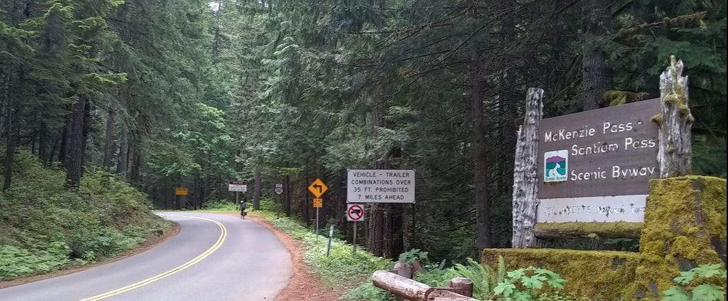
 One of my peripheral goals upon founding Steel Bridge Coffee has been to expand the imagination of what can be accomplished with a bicycle and to inspire more people to use bicycles for practical purposes. While many people are discovering the benefits of bicycle-commuting locally, it is more difficult to imagine an out-of-town vacation without a car. The Pacific Northwest has countless incredible places to visit; is it possible to access the wonders of our region if you're committed to a car-free lifestyle? In this blog post I will describe my and my wife's recent car-free excursion to the McKenzie Pass Scenic Bikeway. McKenzie Highway is a historic scenic route over the Cascades connecting Eugene and Sisters. It is part of the original TransAmerica Bicycle Trail that was mapped out in 1973 and continues to be a favored route for cross-country bicycle tourists today. It is one of about a dozen officially designated scenic bikeways in the state, described by Travel Oregon as “the most spectacular ride in Central Oregon.” The big reason that I was drawn to McKenzie Pass is that for several weeks each spring it is open exclusively to non-motorized traffic. When winter snow arrives the pass closes. In the spring, crews begin plowing the snow and eventually bikes and pedestrians are permitted along the route. In a normal year, the route reopens to motorists on the third Monday in June. Erin and I made plans to bike the highway on a Sunday, the last day before it would open to motorists. At 3:00pm on Saturday the horn sounds to mark the end of the Salem Saturday Market. After a day of serving coffee, we can now taste the weekend. We spend a couple hours cleaning and putting away our market supplies, then load up our panniers and bike three miles to the Salem Amtrak station. We've paid an extra $10 to have our bikes securely stowed in the baggage car (a service available on the Amtrak Cascades train between Eugene and Seattle). The train arrives around 7:30pm and our vacation begins. After a long day of work it's nice to relax in comfort and watch the pleasant scenery of the Willamette Valley roll by. We disembark in Eugene and pedal a mile to the Eugene Whiteaker Hostel, where I've booked a private room for a good price. The hostel—imbued with an artsy, free-spirited aesthetic—brings a nostalgic feeling as Erin and I independently recall various international travels from before we met. The Whiteaker neighborhood is home to three large breweries (Ninkasi, Hop Valley and Oakshire) all within a short walk from our room. We walk a few blocks to Oakshire where I pick up a beer to go, which I enjoy on the hostel's front porch as the sun goes down. Tired from a long day of work and anticipating the next day's adventure, we turn in early. At 7AM we rise, pack up and have a simple breakfast provided by the hostel. We pedal off towards downtown with a quick detour to Wandering Goat Coffee Company to enjoy our requisite coffee fix. It's a Sunday morning and at this hour the streets are very quiet. Our destination is the Lane Transit bus station, one mile away. The hand-drawn map on my front bag is sufficient to get us there without delay. We arrive early and the bus lot is empty save for a few people. The buses have limited space for bicycles, so I'm relieved that we won't have much competition. The bus for route 91 rolls in; it is equipped with a front rack that can stow three bicycles. We load ours on and pay a fare of $1.75 each. Soon we are rolling east through Springfield and eventually out into the countryside. One other person loads a bike onto the third spot before getting off at the next stop. I'm grateful that we didn't block anyone else from loading their bike. The bus ride is pleasant; we enjoy the forested scenery and frequent views of the McKenzie River, as our legs begin to anticipate the challenging bike ride ahead. The bus makes occasional stops in obscure outposts to pick up passengers but on this Sunday there is room to spread out. After an hour and twenty minutes we reach the final stop at the McKenzie River Ranger Station. Here there are a few bicyclists waiting to board the bus and return to Eugene. We talk to one of them who camped at the top of McKenzie Pass the night before and rolled down the hill this morning. He reports that it was very cold and windy there overnight. We watch as three bikes are loaded on to the bus rack and the driver allows a fourth to be stowed on the bus with the caveat that if a wheel-chaired passenger needs to board then the bike will get kicked off. The ranger station is closed but there are portable toilets available and a spigot where we can fill our water bottles. At 10AM the mountain air is fresh and the weather is comfortable, so we ride off with confidence. We're starting at about 1,500 feet elevation. The top of the pass is at 5,325 feet. It's a daunting vertical distance but we remind ourselves that we have all day and the ride down from the top should be easy. The following section contains lots of minutiae from the bike ride. Feel free to skip ahead by accepting this summary: “We bike to the top of the pass and back.” We pedal comfortably along the small shoulder of highway 126 but in a quick mile we turn off onto highway 242, the McKenzie Highway. The road is quiet, smooth and beautiful, however, it is absent of the closed gate I expected to be blocking car access. As we pedal along, a sign indicates to motorists that access will be blocked seven miles ahead. Traffic is very light and respectful of bicyclists. After about five miles of gentle climbing we stop for a quick rest and snack. I have two Clif Bars, a small bag of trail mix and two apples for the day. I realize that I forgot to pack a stash of chocolate chip cookies that I had prepared a couple days ago. I didn't have a big dinner the night before or a big breakfast, so I'm regretting that I don't have a few more calories packed for snacks. I figure that if I get desperate I can always break into my bag of granola that I packed for tomorrow's breakfast. Suddenly, we see our first cyclist come into view. He descends around the bend that is ahead of us and comes flying towards us. He slows slightly as we salute each other in our common mission (his apparently completed). A glimmer of recognition locks our eyes an extra, awkward moment...it's our friend, Keith! He flips a u-turn and we have a good laugh about bumping into each other so far from home. Keith camped out the night before and started his ride around 6:00am. He reports that it was windy and chilly at the top but very beautiful. Erin and I decide that it's time to ride at our own speed. She prefers to ride alone rather than feel like she is slowing me down and I'm hoping I can make it part way down the other side before meeting her at the top. I ride off and settle into a brisk rhythm. After a few miles the gradient steepens but I am able to keep spinning in my middle chainring. I hear that chatter of a couple cyclists approaching from behind. Gradually they overtake me and recede into the distance on their high performance bikes. I'm excited to be riding a vintage machine: a 1974 Raleigh International road bike, made in England from high quality steel tubing. I've made a few modern retrofits while also trying to maintain its historic essence. It's a fast bike but I am carrying two panniers and a handlebar bag with two days of supplies, plus I'm still getting used to the bike's downtube friction shifting. Whatever I may be giving up in speed I am gaining in the sheer pride of riding a bike that turns heads with its classic charm. I continue to climb through the forest and traffic seems to be picking up. Occasionally it is cyclists sailing down the hill but I'm also being passed by motorists, many of whom have road bikes in tow. I can't help but feel like they're cheating. Seven miles up the highway I pass through an open gate. Is it possible that the route is open to cars after all? I overtake a few riders, including a couple of different men on fully loaded touring bikes who are crawling up the hill, notably struggling with their bike's girth. Suddenly a slew of loud motorcycles disrupts my peaceful climb. Just when it's getting to be too much, the last motorcyclist offers me a congratulatory “thumbs up,” and my crankiness is partially allayed. I round a bend and come across a father/son duo walking their bikes down the road. They need a pump but we discover that my vintage pump only works on Presta valves whereas their flat tire has a Schrader valve. I assure them that there are several more cyclists on their way who could surely help. Finally, I see dozens of parked cars ahead and a closed gate. The gate is just past the Alder Springs campground, so presumably some have driven here to camp, while others are launching their ride up the pass from here. I roll past the crowd of men and women geared up in spandex and cycling shoes, and twist my way around the gate to continue my climb. The road seems to steepen from here and its rolling curves submit to more severe switchbacks. At these higher altitudes, the dense forest starts to give way to the occasional panoramic view, however, no mountain peaks are visible yet. Winding up the mountain, I overtake various cyclists on low-performance bikes: hybrids, mountain bikes, an older Schwinn road bike. They have smiles on their faces as they chase the summit without hurry. I pass two young men with commuter-style bikes who are taking a break; as I continue ahead, one of them races up to my side apologizing that he just wanted to get a closer look at my bike. I'm flattered by the attention and we have a brief conversation about vintage bikes before he falls back to join his friend. I cross the 4,000 foot elevation marker still feeling strong. I've gained 2,400 foot and only 1,300 feet remain, so I feel encouraged that I will reach the summit without trouble. However, over the next couple miles a pain develops in my right knee as well as an ache in the left-middle part of my back. Furthermore, my Brooks saddle is not well broken in and is becoming less and less comfortable. When a view opens up I take the opportunity for a quick break. I eat an apple and some trail mix. I don't have as much energy as I hoped for but I'm not concerned about getting to the top. The steep grade continues and I'm finding it more and more grueling to stay on top of my gear. I prefer to conserve energy rather than race to the top, so I finally relent by shifting down to my small chainring and slowing my pace. My bodily pains are taking a toll but the scenery and lure of the summit keep my spirits up. I speculate about my knee pain: the Velo-Orange triple-crankset that I installed to achieve lower gearing has a wider “Q-factor” (i.e. the width from pedal to pedal is wider) than the Campagnolo Nuovo Record cranks that it replaced; the wide Q-factor combined with the crank's straight arms cause my heel to occasionally rub against the middle of the crank when I down-pedal. Perhaps I am compensating by subtly splaying my heel outward, creating unnatural tension on my knees. My back pain I blame on the friction shifting. I've mostly ridden bikes with modern shifters that click between gears with ease from the comfort of the brake hoods. My Raleigh's vintage Campagnolo downtube shifters have the asset of light weight and, more importantly to me, exhibit the aesthetic ideal of simplicity, but they require the operation of a skilled practitioner to work effectively. I'm getting better at operating the levers and am taking pride in it, just as one might take pride in driving a manual transmission car, but I am especially challenged by the down-shifts on my rear derailleur, which require me to swing the right lever downward with enough power to overcome the spring-tension of the derailleur. The force needed to move the lever necessitates a stabilizing counter-force provided by my left arm bracing against the handlebars, which puts pressure on my torso, resulting (I speculate) in the back pain that I'm now experiencing. At my slower pace, I'm getting passed more frequently. Every few minutes I catch notice of a presence behind me and soon a rider is rolling by with enviable ease. These cyclists are riding modern racing-style bikes and are carrying no more than they can fit into a saddle-bag and jersey pockets. I assure myself that they most likely started their ride at the closed gate, 11 miles into my own climb, but still I am disappointed at the speed with which they fade out of view. I round a bend and the forest gives way to a vast, barren opening. I've reached the famed lava field that all the articles mention. It's a neat landscape but for me falls shy of the hyperbolic descriptions that I've read. The gradient has relented here but, no longer protected by the forest, a sharp headwind guarantees that my legs will not be given any reprieve. I ride in the drops for the first time and grit my teeth into the wind. I continue to get passed periodically but I know that I must be nearing the top. I'm encouraged as I approach the 5,000 foot elevation marker and am rewarded by the majestic sight of the North and Middle Sister mountains towering into the clouds. A sign announces that the Dee Wright Observatory (located at the summit) is two miles ahead. I cruise along and then charge my way up one last steep incline before rolling up to the observatory. There are dozens of cyclists here at the top. It's a festive scene. The clouds obscure the peaks of the mountains but still we are treated to incredible views in all directions. I sit on the pavement eating trail mix and stretching my legs, hoping to soothe my aching knee and back. I've come 24.5 miles, which was a few miles longer than I had anticipated. The last seven miles challenged me more than I expected. I take a quick inventory: I'm somewhat low on water and food, and my bodily aches are not yielding to my stretches. I'm lacking great confidence but I put on my long-sleeve wool layer and start to coast down the east side of the mountain. As my bike sails ever more rapidly downward, the thought of retracing my way upward grows more daunting. I make it only two miles before deciding that I'm content with my brief dalliance with the east side. In an ideal situation, I would ride the entire course down to Sisters, 13 miles from the summit, but we are constrained by my two-day weekend and our commitment to avoid using a car. If I felt especially ambitious, I could ride the whole way and back in a day, but I'm not inspired by the thought of seeing the same scenery twice. Riders coming from the west side of the mountain have the option of paying for a shuttle (around $50) to get them and their bikes to Sisters, allowing them to ride up the easier side of the mountain and coast down the steeper and longer west side. This is a tempting option because then you get the full experience of seeing the landscape change from high-desert and pine forest to the wet and dense fir forests of the west side. As I crawl my way back to the summit, I wonder how my wife's climb is going. If the ride has put me into some difficulty then I have reason to worry about her spirits. It's possible that she's wanting to turn back but we're supposed to meet at the top and she has no way to communicate with me if she changes her plan. I crest the summit and start my way down the west side. After a couple of miles my speed quickens with the slope of the road. Soon I am sailing down the road that I labored so hard to conquer. Finally, almost five miles from the summit, a familiar headlight comes into view. In the distance, I can make out my wife's smile as she sees me roll towards her. Erin declares that the ride is very, very hard and takes opportunity to remark on the disingenuousness of all the well-meaning folks who assured her that she would be fine. I tell her that we can turn around anytime she needs to but that there's plenty of time to keep progressing. We ride together slowly and tell a few stories from the day's ride. The camaraderie helps to obscure our physical fatigue, however, we both complain that our seats are becoming very uncomfortable. Erin is getting tired and the supposed bragging rights of reaching the summit inspire her less than the prospect of summarily ending her physical suffering. I tell her that she can turn around if needed but that she might want to at least make it another mile to the first mountain viewpoint. We reach the viewpoint and stop for a rest and a picture. Erin is content that she's essentially reached the top. We're two miles from the actual summit and in the face of her eagerness to head back I switch strategies telling her that she's simply too close to turn back. With grudging forbearance she yields to my heavy-handed persuasion. Now we're a mere mile from the summit but as the road steepens my cheery attitude becomes unbearable to my wife. She instructs me to go ahead and wait for her at the top. I know that disobedience is not an option, so I cruise ahead. It's almost three o'clock and there are only a smattering of people at the summit. It is clearly past “rush hour” when droves of cyclists were reaching the top. It's less windy than earlier and somewhat less cloudy. The mountains are glorious, though clouds still block the upper tips of the Sisters. I watch proudly as Erin rolls towards me and dismounts her bike. I ask how she feels upon reaching the top, perhaps expecting a hint of gratitude that I helped motivate her to achieve her goal. Instead, with an air of cynical pragmatism incongruous with the awe-inspiring summit, my wife quips that she feels like she could have turned around two miles ago. Nevertheless, we linger at 5,325 feet for a good half hour, walking leisurely up the observatory and enjoying a 360 degree view of the Cascades. The observatory, constructed of lava rock, is a spectacular structure that seems to both blend in with and accent the awesome landscape. The top tier of the observatory is in the open air whereas the middle tier is walled in with labeled openings cut into the lava rock, which peer out at particular points of interest, most prominently Mt Jefferson, Mt Washington, and the North and Middle Sister; apparently Mt Hood would be visible on a clear day. I expected to see the South Sister but it must be hiding behind her attention-seeking siblings. At 3:15 we begin our ride back down the mountain. It is fun to cruise down with little effort. We quickly notice that at coasting speed my bike surges ahead of Erin's bike. The difference is quite staggering. Apparently, in addition to not being a natural athlete, she has been handicapped by a slower bike. I wonder what is making the difference. She has brand-new Schwalbe Marathon tires that I installed for their durability and resistance to flats. Compared to my thin and supple Panaracer Pacenti tires, the Schwalbes must have considerably more rolling resistance. We both have front generator hubs that power our lights, however, my bike has a more expensive hub made by Shutter Precision, compared to here cheaper Sanyo hub. I don't believe that the hubs have a great difference in efficiency, however, I wonder if her front headlight, which is a very old Busch and Muller model draws more power from the hub than my brand new headlight. I realize that I should have advised her to turn the light off during the climb. I try to slow my pace on the straight sections of road to keep from rolling out of sight. On the tight switchbacks, however, Erin keeps pace with me as we both must use our brakes to control our speed anyway. It's really a fun descent. The grade is never steep enough to feel dangerous and we are mostly able to just let our bikes fly with minimum input. As we get closer to the main highway it is clear that a rain has passed through. The road is very wet. Fortunately my bike is equipped with fenders and the moisture stays off my body. We reach highway 126 and survey our options. We've rented a cabin by the town of McKenzie Bridge (to the left) but the official “scenic bike route” goes another mile to the right, ending at Belknap Hot Springs and Lodge. We likely would have booked a room at the lodge for this night except the nearest restaurant was five miles away in McKenzie Bridge and we knew that a 10-mile round trip ride for dinner was going to be unwelcome. We would love to take a soak in the hot springs here at the end of the ride but we elect for the direct route to our cabin and to the restaurant. We head west down the highway and soon pass the ranger station where we started our ride. McKenzie Bridge is three miles further. On some parts of the highway, the shoulder is a bit narrow for comfort. We are adjacent to the McKenzie River Trail—a popular mountain biking route—but there are limited access points and our road bikes are probably happier on the highway anyhow. Soon we hit the edge of town and hang a left towards Horse Creek Lodge where our host directs us to our cabin, which is unlocked and waiting for us. We shower and then immediately bike a half mile to the “McKenzie General Store,” which is both a grocery store and restaurant. Sitting down to a calorie-rich dinner is the perfect treat at the end of a rigorous ride. On our way out we purchase some snacks and beer to enjoy at the cabin, as well as some yogurt for our breakfast the next day. The Horse Creek Lodge cabin is a lovely place to relax and wind down the evening. There are various cabins here but it's very peaceful and we don't notice many other tenants. As dusk approaches we hear a roll of thunder and soon it is pouring rain. I cherish the opportunity to sit on the porch—comfortable and dry—as sheets of rain saturate the forest around me. We fall asleep with the windows open. In the morning we have a couple hours to relax with our breakfast and our reading. Naturally, I've bothered to bring my coffee gear. I hand-grind some fresh Steel Bridge beans and prepare a pour-over coffee. The bike ride was exciting but for me this is the kind of moment that makes the trip worth it. We're only 80 miles from home, as the crow flies, yet it feels a world away. I'm glad we could create that feeling in such a short time and with our automobile still parked in our driveway. I bask in that satisfaction as I sip my coffee on the porch. We have time for a short walk to the river before packing up our things and saying goodbye to the cabin. At 10:00am we are across from the general store, waiting for the bus. Since it is now a Monday, I doubt that we have to worry about any cyclists loading their bikes at the ranger station. Indeed, the bus arrives with no bikes on the rack. As we make our way towards Eugene, the bus slowly fills up with commuters. It's clear that this is a better used bus than the rural routes I've ridden out of Salem, which often have only a few people on board. I wonder what the difference is. Once in Eugene we have four hours to kill before catching the train home. We're excited to explore a few places, eat more good food, and relax. We eat a snack downtown at “Off the Waffle,” one of Erin's favorite Eugene hot spots. Then we bike towards Skinner Butte. Yesterday's ride was the longest each of us had ridden on our new bike seats and today we can really feel it as each mile is a bonus test of endurance but apart from these pressure point pains, our legs are still feeling fresh. We casually walk our bikes up the road to the top of the butte and enjoy the views of the city. Then we roll down and relax in the ample greenspace along the Willamette River. Next we head to McKenzie River Brewpub for a late lunch and contentedly work our way through our substantial portions. It's graduation weekend at the University of Oregon and we observe various families treating their sons or daughters to a celebratory meal. We take another jaunt by the river, crossing over a pedestrian bridge into Alton Baker Park. Eventually, we find a spot to nap in the grass before heading to the train station. Regrettably, there is a problem with the train route between here and Salem, so Amtrak is providing buses to shuttle past that section of the route. Our bikes get stowed in the bottom carriage of the bus and we settle in for the drive home. Back in Salem, we pedal the familiar roads through downtown, across the bridge, and to our home in the Edgewater neighborhood. I look at my phone; it is 6:30pm, exactly 48 hours since we left home. It's been a fulfilling two days!
2 Comments
|
|